A personal blog by Ackworth born Gerald England who married a Lancashire lass, went West and now lives in Cheshire.
Showing posts with label Roads. Show all posts
Wednesday, November 11, 2015
ABC Wednesday: R is for
Road Train at Rest And Be Thankful
From Llandudno there is a Road Train you can catch that will take you on a tour of the Marine Drive a road that goes around the side of the promontory known as the Great Orme. At the top it breaks the journey with a 15-20 minutes stop at "Rest and be thankful" where there is a small café.
The view looking west ranges towards the island of Anglesey with the smaller Puffin Island visible just off shore.
Looking slightly east of north the view shows the top of a former lighthouse that has since been converted into a guesthouse.
Looking east rain can be seen coming over the wind turbines in Liverpool Bay whilst on the right is the Little Orme.
This shows the rear of the Rest and be Thankful where most people from the road train and the red car in the car park are partaking of some refreshments.
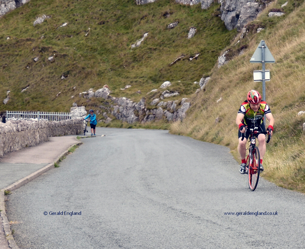
And finally a look at the road and two riders tackling the climb on their cycles.
A contribution to ABC Wednesday
and Wednesday Waters.
Friday, March 06, 2015
Hail on Hyde Road
The A57 at Crown Point, Denton. On the right is the entrance to Morrison's supermarket. The fence separating the pavement from the busy road is reflected in the window of the Quicksilver fireworks shop. A shower of hail is just falling but failing to stick.
A contribution to
Good Fences;
Skywatch Friday;
Weekend Reflections;
Scenic Weekends
Wednesday, September 17, 2014
ABC Wednesday: J is for
Jutland Street, Manchester
Still cobbled (or more accurately stone-sett), Jutland Street is supposedly the steepest street in Manchester. It leads off Store Street and crosses the Ashton Canal before ending on Ducie Street.
Here is how it looked in 1996. Photograph © Aidan O'Rourke and used with permission.
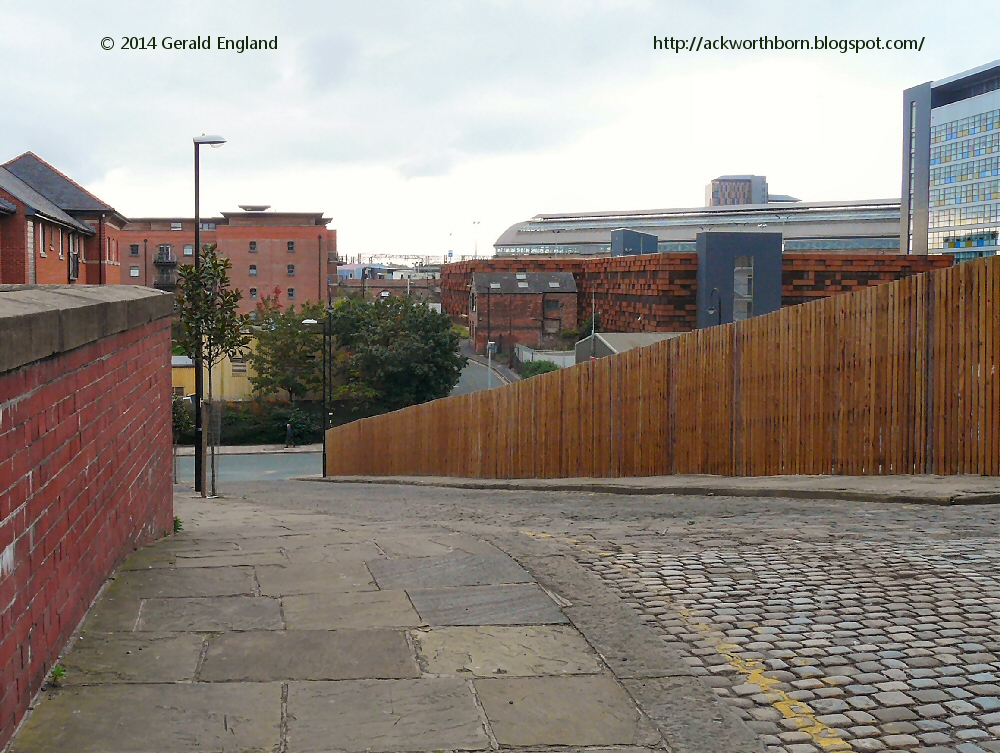
This is the view looking down towards Store Street from the top of the canal bridge.
Looking east from the bridge is Paradise Wharf on the Ashton Canal. The narrowboat "Moorhen" is moored by the canalside apartments at the end of an aqueduct which carries the canal over Store Street towards Great Ancoats or as it now prefers to be called, New Islington.
Looking west from the bridge is Ducie Wharf where the Ashton Canal ends by turning right under Ducie Street into the Rochdale Canal. The towpath here under the shelter of the highrise apartments are home to a number of Manchester's rough sleepers and their canine companions. Beyond the car parks on the left is Piccadilly Station.
A contribution to
Outdoor Wednesday;
Water World Wednesday;
ABC Wednesday;
Skywatch Friday;
Weekend Reflections.
Thursday, March 20, 2014
Caroline Street, Foxhall, Blackpool
The street-name signs in the Foxhall area of Blackpool are of this interesting design.
Caroline Street is on the corner of Princess Street just up from bridge featured in my post of March 16th.
A contribution to signs, signs.
Sunday, March 16, 2014
Princess Street Bridge, Blackpool
This is the bridge over Princess Street looking west. It originally carried the railway line between Blackpool South and Blackpool Central stations.
This view is looking east. The railway line closed in 1964 and in the 1980s a road was built along the trackbed.
The former sidings approaching Blackpool Central have been converted into the Central car and coach park. The eastern parapet of the bridge can be seen on the right. The western portal is set back behind the hoardings on the right.
On the inside of the western parapet of the bridge is some graffiti/street art. I suspect this dates from 2012 but I haven't been able to confirm this.
This image from Streetview shows how it looked in 2009.
A contribution to Sunday Bridges at San Francisco Bay Daily Photo and Monday Murals.
Sunday, October 21, 2012
Sunday Bridges: Norbury Viaduct, Hazel Grove
This bridge over Macclesfield Road leads on to the Norbury viaduct. Just beyond the bridge on the left is the terminus of the 192 bus service to Manchester. It carries over nine million passengers each year, and is considered by many to be the busiest bus route in the country - see Wikipedia.
Established under the arches of the viaduct since 1982 is the used-car salerooms of the Midland Garage.
The viaduct was built by the Midland Railway as part of the New Mills to Heaton Mersey line, which formed part of its main line between Manchester Central and London St Pancras.
At the end of the viaduct is the bridge over the A6, Buxton Road.
Like all railway bridges in the UK it carries a notice detailing who to contact in the event of any damage caused to the bridge by striking vehicles.
A final look back at Buxton Road bridge from the other side.
An old view of the viaduct can be found on the Stockport Image Archive.
For more bridges, visit Sunday Bridges at San Francisco Bay Daily Photo.
Wednesday, June 01, 2011
ABC Wednesday: T is for
Tan Yard Brow & A Google Streetview Car

Tan Yard Brow in the East End of Manchester used to be an ancient North-South route, but nowadays it is a badly made up road. Some weeks ago I was walking down Tan Yard Brow when a Google car passed by filming for Streetview.

It had to crawl along as due to the state of the pavement and roadworks along one side pedestrians were forced to walk in the roadway. That gave me plenty of time in which to photograph the car. Tan Yard Brow is blocked off to vehicular traffic just around the bend where the road crosses the Gore Brook. In this direction it has long been restricted in order to prevent the route being used as a "rat run".

The Google car had to turn round at the bottom and here we see it turning left into Hyde Road. Right turns are not allowed due to the traffic jams it would cause near the busy junction by Debdale Park.
For more T posts visit ABC Wednesday.
Wednesday, March 30, 2011
ABC Wednesday: K is for
Kings Road, Audenshaw

Kings Road was constructed as an access during the building of the Audenshaw reservoirs in the 1880s. Kings Farm lay to the East (left) of Kings Road under the shadow of the #3 reservoir. When the M60 motorway was built, the #3 reservoir was reduced to allow the motorway to come through. The motorway embankment seen here is where the reservoir embankment used to be. When this photograph was taken in May 2009 the land on the right was "earmarked for development".

By the time I revisited in May 2010 construction of an estate of new houses had already begun. The rest of the photographs in the post are from a walk taken a few days ago starting in the opposite direction along Kings Road.

Another 12 months on and the new houses can be seen from near Fairfield Golf Course.

This shot shows the strip of land between Kings Road and the M60. Some 22 acres of land, originally reservoir embankment were used for grazing cattle.

On the West side of Kings Road lies Fairfield Golf Club and Gorton Upper Reservoir. on the other side of the reservoir lies the Wright Robinson Sport College. The school which preceded the college was built in 1961 on land previously part of the golf club. In compensation Manchester Corporation Water Works took 50 acres of land from Kings Road Farm and allocated it the golf club.

Cornhill Lane leads off Kings Road by the side of an electricity substation. To the North of the lane is the Eastern section of Fairfield golf course. Most of the land South of Cornhill Lane is occupied by Denton golf course.

Kings Road ends when it meets Debdale Lane where it crosses the South-eastern corner of Gorton Upper Reservoir.
I wrote about Gorton Lower Reservoir in February 2009 and again in October 2009. There is more I've learnt recently about these reservoirs but it will have to wait for another day.
More information about Kings Road Farm can be found on the Audenshaw Local History website.
You can view the 26 photographs that make up my walk last Monday (with a map and slideshow available) on the Geo-trip website.
More K posts can be found at ABC Wednesday.
Wednesday, February 09, 2011
ABC Wednesay
D is for Disruption on Droylsden Road
I've missed a couple of weeks having been busy getting to grips with a new computer, but I'm a bit more sorted again now.
This is Droylsden Road, Audenshaw from the top deck of a #216 bus from Ashton under Lyne to Manchester, last September.
A new Metrolink tramline is being built through Droylsden. For part of its route the trams will run down the middle of the main road. The construction is therefore causing much disruption.
I did have this and another photograph from further down the line earmarked for the M post last round but chose to go with something else on the day.
You can see more of the disruption in my photograph on sithenah.
For more information on the line itself see http://www.lrta.org/Manchester/ashton.html.
Visit ABC Wednesday for more D posts.
This is Droylsden Road, Audenshaw from the top deck of a #216 bus from Ashton under Lyne to Manchester, last September.
A new Metrolink tramline is being built through Droylsden. For part of its route the trams will run down the middle of the main road. The construction is therefore causing much disruption.
I did have this and another photograph from further down the line earmarked for the M post last round but chose to go with something else on the day.
You can see more of the disruption in my photograph on sithenah.
For more information on the line itself see http://www.lrta.org/Manchester/ashton.html.
Visit ABC Wednesday for more D posts.
Wednesday, January 19, 2011
ABC Wednesay
A is for Arran
The island of Arran lies off the Ayrshire coast. This is the view from near Ardrossan where a ferry sails to Brodick.
The A841 encircles the island going North from Brodick to Sannox before cutting through Glen Chalmadale.
At the Northwest corner we come to Lochranza with its ancient castle.
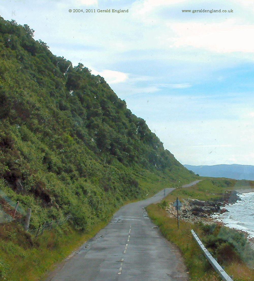
Turning South the road became single track with passing places in June 2004 when these photographs were taken. I recently looked at this road in Streetview and it seems to have been improved now.
The Southwest of the island around Blackwaterfoot is more rural. This is looking back towards the mountainous North of the island.
Having rounded the South end of the island the road heads North towards Lamlash Bay.
For regular views across to Arran from the Ayrshire coast see Bill Anderson's Ayrshire + Photographs.
Visit ABC Wednesday for more A posts.
The A841 encircles the island going North from Brodick to Sannox before cutting through Glen Chalmadale.
At the Northwest corner we come to Lochranza with its ancient castle.
Turning South the road became single track with passing places in June 2004 when these photographs were taken. I recently looked at this road in Streetview and it seems to have been improved now.
The Southwest of the island around Blackwaterfoot is more rural. This is looking back towards the mountainous North of the island.
Having rounded the South end of the island the road heads North towards Lamlash Bay.
For regular views across to Arran from the Ayrshire coast see Bill Anderson's Ayrshire + Photographs.
Visit ABC Wednesday for more A posts.
Wednesday, November 24, 2010
ABC Wednesday
S is for Spring Gardens

Spring Gardens is at the heart of the Victorian business centre of Manchester.
For a closer view of the top of the buildings see sithenah.
For more S posts visit ABC Wednesday.
Wednesday, July 28, 2010
ABC Wednesday
B is for Basel

We passed through Basle/Basel on our 2002 Eurpean Coach Tour.
The city then seemed grey and sombre. A lot of building work was going on, including the construction of many tunnels to take traffic under, rather than through, the city. We crossed the Rhine and then dived under a tunnel to come out at a large service area, Autogrill Pratteln, which straddled the motorway.

Here we had a long stop. I went over to the other side to change some sterling into Swiss Francs. The service area was packed with people thronging the various shops. I purchased two bananas and two apples from a stall and then we went for some lunch in the self-service restaurant. Two glasses of apple-juice plus one Schnitzel and french-fries cost an amazing twelve pounds. It was however large enough and tasty enough to split in half and satisfied both our hungers.
Since then I've discovered Yvi's Photography and can find all the things we missed.
For more B posts visit ABC Wednesday
Sunday, July 25, 2010
Shadow Shot Sunday:
Pippin Street Roundabout

On our way back from Southport last week our coach was diverted along the B5242 from Scarisbrick to Burscough.
While stuck in traffic at the Pippin Street Roundabout I took this photograph through the window.
I didn't know what this was but after a lot of googling (most of it futile) I eventually discovered Tollgate Road leads from the roundabout to the Burscough Industrial Estate. The roundabout features an eyecatching design linked to the estate's history as a former military airfield. The main element of the design is the use of wing-shaped markers, which have been designed as a reference to the Fairey Firefly fighter plane flown from the site in World War II.
There is another view of the roundabout on Geograph.
For more shadows shots this Sunday visit Hey Harriet.
Wednesday, July 21, 2010
ABC Wednesday
A is for Alan Turing Way

Before the building of the City of Manchester Stadium, visible on the right, the A6010, the Manchester Inner Ring Road, ran along Forge Lane. When the area was redeveloped in 1994, a new stretch of road was built along the almost parallel line of Mill Street a little further West. Both Mill Street and Forge Lane disappeared during the creation of Alan Turing Way named after the mathematician.
In 1949 as deputy director of the computing laboratory at the University of Manchester he worked on software for one of the earliest stored-program computers, the Manchester Mark 1. His Turing test was a significant and characteristically provocative contribution to the debate regarding artificial intelligence.

The river Medlock passes under Alan Turing Way after which it flows through a culvert under the stadium, built for the 2002 Commonwealth Games and now the home of Manchester City Football Club.

This view is looking back up the road past the entrance to the stadium towards the gasometer which was the area's iconic landmark prior to the building of Sports City as the stadium was first called.
For more about Alan Turing (1912 - 1954) I recommend starting with the excellent Wikipedia article.
For more A posts visit ABC Wednesday.
Wednesday, June 16, 2010
ABC Wednesday:
V is for Viaduct at Woodley

The viaduct at Woodley is a bit of a hidden wonder insofar as there isn't a vantage point (as far as I'm aware) from which one can see the whole of it.
This view from Manor Road is looking at the eastern end of the viaduct as it crosses Hyde Road.

Here now is the view looking from Manor Road through the archway towards Hyde Road.
After Manor Road the next archway crosses the Peak Forest Canal. You can see the underside of it on the photograph I posted in July 2009.

On the day I took these photographs I walked down Manor Road and crossed the canal using Bridge #12 and walked back to Hyde Road along Bankfield Road, crossing under the fourth arch. This view is looking back at the viaduct.
The railway used to be the main line from Woodley to Stockport (Tiviotdale) and points West, but now the line terminates at a nearby industrial area.
For more V posts visit ABC Wednesday
Subscribe to:
Posts (Atom)